
We headed south today to explore the Oregon coast a little more. There was only one other lighthouse on the Oregon Coast we had not seen, Cape Blanco, so we thought we'd make that our first stop. Well, we didn't get too far south of Bandon when we spotted an Ocean Spray Cranberry farm. Now, I had no idea what a cranberry plant looked like and neither did Debi, so we decided to find out. Farther on down the coast, we toured the lighthouse, went to Arizona beach, Port Orford and walked on the beach at Ophir, just north of Gold Beach. Interestingly enough, when we left Bandon this morning, gas was $3.57/gal..when we returned, it was $3.68 ! Pretty sad....


Everyone has had cranberries during Thanksgiving Dinner but have you every thought about where they grow? We didn't know if they grew on trees, bushes, in the ground or what. So, we decided to find out. We met a very informative cranberry farmer named Foster. He gave us a mini-cranberry education. Cranberries grow on low lying bush type plants very close to the ground. He called them cranberry grasses. They need to be kept moist during growing season and their fields are called "bogs". What moisture Mother Nature fails to provide, they must supplement with irrigation. Too much water and the fruit becomes mushy and unusable. Too little water and the fruit doesn't ripen well or may die. Maintaining the proper moisture in the soil is crucial to having a successful crop.
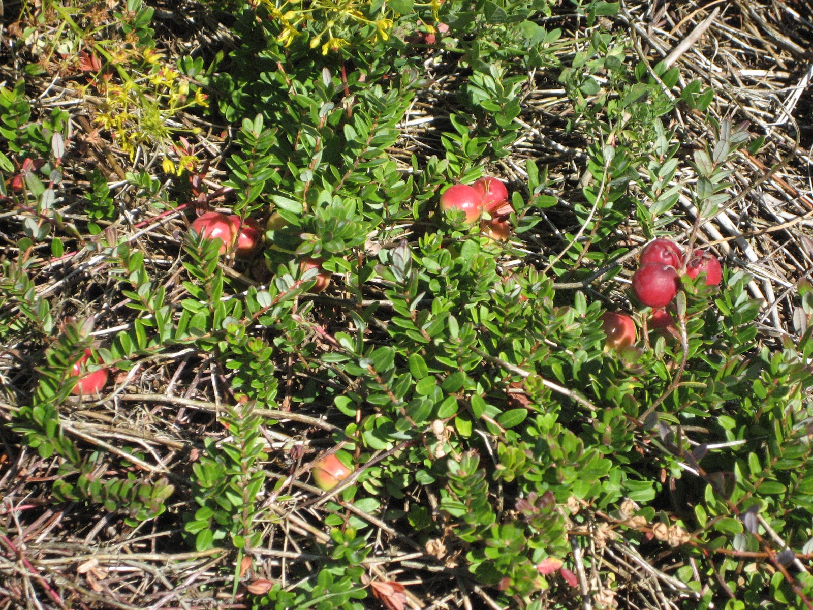 During our travels, we see many crops growing in various States and areas within those States. We've often wondered why, since it seems so simple, farmers don't put small signs on their fences indicating what crop they are growing. The only one's we've seen was a sign saying it was "Corn"....well, practically everyone knows what a cornfield looks like.... we want to know what a potato, beet, cauliflower, broccoli, or a cranberry look like. For those who have wondered the same thing, here is a picture of a cranberry field or "bog".... below that is a picture of the plant itself.....
 Next up, we visited the Cape Blanco Lighthouse. This is the 9th and last
lighthouse along the Oregon Coastline. I have found the tour very
interesting. Lighthouses were and in many cases, still are, important
pieces of navigation. The construction, workmanship and labor intensive
duties of the lighthouse keepers is amazing. Today we have everything
automated and of course are now trending toward GPS units that
lighthouses eventually will have outlived their usefulness. For now,
though, it's amazing to visit them and marvel that these lights can be seen up to 20 miles out to sea.
Next up, we visited the Cape Blanco Lighthouse. This is the 9th and last
lighthouse along the Oregon Coastline. I have found the tour very
interesting. Lighthouses were and in many cases, still are, important
pieces of navigation. The construction, workmanship and labor intensive
duties of the lighthouse keepers is amazing. Today we have everything
automated and of course are now trending toward GPS units that
lighthouses eventually will have outlived their usefulness. For now,
though, it's amazing to visit them and marvel that these lights can be seen up to 20 miles out to sea. This lighthouse hold several distinctions. First, it's the oldest continuously operating light, it is the westernmost point on the Oregon Coast, it has the highest focal point above the sea at 256', and had the first woman keeper in 1903. It was built around 1870 and has been in operation ever since. The light originally was oil based, then switched to kerosene and finally to electricity. This is a 1,000 watt incandescent bulb that burn continuously. The lens that you see surrounding the light rotates to magnify and intensify the light. This lens is 4'8" in diameter and 6'8" tall. As the lens rotates, the magnification increases depending on the position of the lens, ultimately producing a 320,000 candlepower beam of light!
 This lens was the invention of a Frenchman named Fresnel. He found that through the use of prisms, he could focus the lost light above and below the light source and redirect that light back into a single beam of light. This light is then focused through the center of the lens creating a highly visible beam of light. Here we are looking up towards the top of the lens at the many prisms designed to redirect that light.
Because the lens used magnification to create the beam, during the day, sunlight coming through the lighthouse windows became magnified also. This created a very hot environment inside the lighthouse tower, so drapes were installed to block the sun.
One of the keeper's jobs was to clean the windows daily. The railing in the background was for their protection.

Another picture of the Oregon Coastline looking south towards California....Notice the unspoiled beaches, little surf and no people...!

We found these rocks off the coast near Port Orford, Oregon. If you look closely, the centermost rock resembles a whale with it's head facing the coast and it's tail raised out of the water....you may have to double click the picture to enlarge it to see the resemblance.

Port Orford is a unique place. The town was originally formed in 1856 and was a receiving port for mercantile and fishing. It was also used as a shipping port for timber. The port is an open water dock (no natural protection) and boasts the only dry dock port on the West Coast. The fishing boats are lifted in and out of the water by cranes and set on custom-made dollies and parked in rows on the dock. As a result, it is known as a "dolly dock. You can see one of the boats being lifted if you enlarge this picture.

Here is a picture of Arizona Beach, south of Port Orford and north of Ophir, Oregon. A beautiful day use beach, suitable for kids and adults alike. The waves were subtle and there is a large warm and shallow lake between the parking lot and the ocean.

Heading back to Bullard's Beach we found this meadow with cows feeding leisurely in the field. I found it especially picturesque away from the ocean and the busy towns along the coast.

Almost back to the campsite, I noticed these geese who, like us, were headed back to the warmth and comfort that we call "home". A perfect ending to a perfect and very relaxing day....
No comments:
Post a Comment