
We spent Memorial Day in Rifle Gap and then headed for Denver. I was a little apprehensive about this stage of our adventure as I had never taken our coach up and over the Rockies with its' high elevations. My concerns disappeared after the first real climb as the coach performed flawlessly and with the two stage engine brake, coming down was actually pleasurable. Here's some pictures between Rifle, Colorado and Denver....

The State Park is situated a few miles north of I-70 and surrounds a reservoir. The road to the Park crosses the dam and is a narrow two lane road. Upon crossing the dam, we encountered several cowboys that were herding these cows down this road at high noon! What were they thinking? We stopped to allow them to pass but they parted the herd so we could proceed. There were about 50 vehicles stopped waiting to go the other way. I did get some cow snot on the rig while we were stopped talking to the cowboys!

Once past the cattle drive, we headed south and then east on I-70. We had a few puffy clouds but no wind! This is interesting country as the elevation of Rifle is 5,380 feet, about the same as Denver, and I-70 begins its' ascent into the Rockies from here. The road passes through relative flatlands surrounded by small hills.

Heading east on I-70, the road starts to climb into Glenwood Springs, an enjoyable town with many small shops, hotels and a large hot springs hotel/swimming hole. Amtrak also has a station there. The road follows the Colorado River and was an engineering feat when it was completed. I-70 originally was designed to stop at Denver as it was felt the road through Glenwood Canyon was too narrow and winding for an Interstate. In fact, I-70 is the only road that varies from the norm for Interstate travel, relating to curvature and grades.

In order to build the Interstate through Glenwood Canyon several tunnels and bridges had to be constructed. Of interest is the shape and construction of the tunnel for the roadway compared to the chiseled features of the railway tunnel depicted in the previous picture.
There are signs posted along this portion of the highway alerting motorists the roadway does not meet Interstate standards.

Here, eastbound traffic is cantilevered above the Colorado River while
westbound traffic is suspended on a viaduct above the canyon floor.

After passing through the 12 mile stretch of Glenwood Canyon, we left the sheer cliffs behind and discovered beautiful rolling hills and wonderful villages nestled in the valleys. Towns like Eagle, Edwards and Avon. Most of these towns were the result of gold and silver being found in these mountains back in the 1800s. They are thriving today because of Colorado's "White Gold"...we call it snow....

Continuing east the road begins to climb again. Two large sharp curves await ahead before starting the big ascent over the Rockies. Here, we are arriving just west of the city of Vail, Colorado.

The highest point of I-70 is the Eisenhower/Johnson tunnel. The westbound tunnel is named Eisenhower, after the president, completed in 1973 and the eastbound is named Johnson, after the governor of Colorado who lobbied for it's construction, completed in 1979. Elevation is just over 11,000 feet. The tunnels are 1.6 miles long and are sloped at almost a 2% grade. The tunnels pass underneath the Continental Divide.

After exiting the tunnel, there is a pull out to view the expanse of the Rocky Mountains. It is also a place to check your rig in preparation for the 7-8% downgrades and sharp curves that await ahead. The Loveland Ski area is just below us here. We stretched our legs, gave Jasmine a bit of a walk and ate lunch before continuing.

Coming off the summit, we passed towns like Georgetown, seen here, Clear Creek and Alvarado before dropping down to Denver. As picturesque as this area is, make no mistake, the road is long and steep with many sharp curves. Our coach handled well and all my worries were for nothing. With the engine brake on low, I was able to maintain a steady 50mph speed.

Along this stretch of I-70 there are over 40 tunnels and bridges. Several of the tunnels are built along this long downgrade. Notice the sign here that warns truckers of "Sharp Curves 2000 ft. ahead"...

The interesting thing about this long and tedious downgrade is that Denver can be seen in the distance which gives the impression that you are done with the steep grades and sharp curves. These signs are testimonials that driver's were not prepared for the curves that were still to come.

A final warning that more curves and steep grades lie ahead.

Finally, after passing over the highest points of the Rockies, we dropped down into Denver. Of course, with the "big" city, we also encountered traffic.

Like most big cities, Denver has it's share of high rises, apartment buildings and office towers. Denver is the largest city within the State of Colorado and is home to more than 600,000 people.
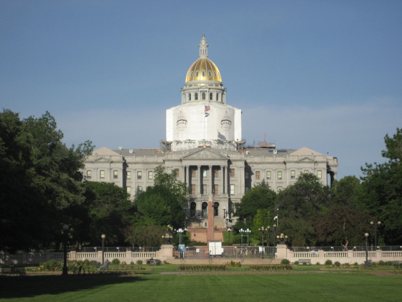
It is also the State Capitol of Colorado. It encompasses 155 square miles, is the second largest city in the Southwest, (behind Phoenix, Arizona), and is exactly 5,280 above sea level, which gives it the nickname "Mile High City".

It is also the home of the US Mint. The Denver Mint is the single largest producer of coins in the world. The mint struck its first coins in 1906 and each coin bears the letter "D" mint mark. Its first year of production produced 167 million coins, including the $20 Gold "Double Eagle", $10 Gold "Eagle" and the $5 Gold "Half Eagle".
The Mint offers free tours of the facility every hour 8am-2pm M-F. Sorry, no FREE SAMPLES...!!
No comments:
Post a Comment